Tip
Welcome to Simcountry.
close
Loading message...
Confirm
Confirm
Cancel
Title
Applet Window
Maximized Window
UPLOADING IMAGES AND SOUNDS
Uploading images and sounds is restricted to Premium Members.
Please return to this page after you made a contribution to the game.
Simcountry Popup
Kebir Blue: Aug 11 5602
Home
Communication
Chat
Forum
Account Status
Account & Membership
Direct Trading
Boosters
Gold Coins
My Country
My Enterprise
My Messages
Space Program
Loans
Shares
Common Market
Security Council
Sitemap
Game News
Beginners Support
Documentation
Logoff
The Republic of Para sankta
President: Simcountry
videos
Army
War Protection
:
No war protection
War Experience
:
Level 0
Finance Index 78.61
Cash:
-102.02B SC$
Profit/Loss:
-9.14B SC$
Total Assets:
15.66T SC$
Country Assets
Population:
29,969,594
Migration:
667
Corporations:
21
Gold Coins:
Nat Resources
Newspapers
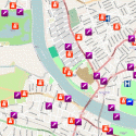
Show Map
Country Map of "The Republic of Para sankta"
Map Control
Legend
Show Map with default Icons
World Map
Continent
Region
Big Country Map
Map of All Wars
Enemies Map
Map of Allies
Navy Maps
StreetMap of the Capital
Change Visibility Country Map Objects
Show or Hide Objects
Show or Hide Roads and Train Tracks
Change Map Icons
Cities, factories and military objects in The Republic of Para sankta
Object
Name
Coordinates
Damage
Army Unit
Bonita
60.53°S 56.50°W
0.0%
Army Unit
Concord
60.58°S 56.50°W
0.0%
Capital
Remy
60.69°S 56.52°W
0.0%
City
Conway
60.69°S 56.71°W
0.0%
City
Dolinde
61.14°S 57.18°W
0.0%
City
Ellorlon
60.98°S 56.85°W
0.0%
City
Elta
61.30°S 56.42°W
0.0%
City
Enothlond
60.97°S 55.58°W
0.0%
City
Galne Thalore
60.83°S 55.59°W
0.0%
City
Honione
60.51°S 56.98°W
0.0%
City
Indio
61.45°S 57.06°W
0.0%
City
Madon
60.41°S 55.48°W
0.0%
City
Merwed
61.15°S 55.71°W
0.0%
City
Onegron
60.43°S 56.50°W
0.0%
City
Orwin
61.10°S 56.11°W
0.0%
City
Ronat
61.32°S 54.76°W
0.0%
City
Saratoga
60.56°S 55.43°W
0.0%
City
Thellonde
60.40°S 55.93°W
0.0%
City
Zossen
60.85°S 56.46°W
0.0%
Corporation
Alfreda Furniture
60.69°S 56.25°W
0.0%
Corporation
Arran Defensive Missiles
60.69°S 55.51°W
0.0%
Corporation
Asugi Armored Vehicle Missiles
60.71°S 55.97°W
0.0%
Corporation
Bellona Meat Products
60.41°S 56.41°W
0.0%
Corporation
Bongor Airforce Maintenance
60.86°S 56.75°W
0.0%
Corporation
Clifton Electric Components
60.68°S 55.06°W
0.0%
Corporation
Darongo Off Weapons Maintenanc
60.84°S 55.88°W
0.0%
Corporation
Dotamunda Roads
60.54°S 55.29°W
0.0%
Corporation
Dovra Defensive Missiles
60.09°S 56.10°W
0.0%
Corporation
Halle Ammunition Quality Upgra
60.83°S 56.34°W
0.0%
Corporation
Huamu Cars
61.13°S 55.00°W
0.0%
Corporation
Juterborg Defensive Missiles
60.24°S 56.02°W
0.0%
Corporation
Kanje Furniture
60.83°S 56.94°W
0.0%
Corporation
Kori Roads
61.28°S 56.09°W
0.0%
Corporation
Mills Military Bases Maintenan
60.27°S 55.86°W
0.0%
Corporation
Noyo Construction
60.85°S 54.99°W
0.0%
Corporation
Sheraza Factory Maintenance
61.14°S 56.49°W
0.0%
Corporation
Springhill Highschools
61.16°S 54.85°W
0.0%
Corporation
Sunnyvale Chemicals
60.98°S 55.78°W
0.0%
Corporation
Tacro Elementary schools
60.54°S 55.74°W
0.0%
Corporation
Westglamor Cars
60.85°S 56.62°W
0.0%
County
Alfreda
60.72°S 55.81°W
0.0%
County
Carson
60.41°S 56.70°W
0.0%
County
Clement Ontario
61.00°S 57.46°W
0.0%
County
Detmold
61.17°S 56.04°W
0.0%
County
Edison
60.25°S 55.72°W
0.0%
County
Gronneka
60.54°S 56.50°W
0.0%
County
Ivenote
61.45°S 56.62°W
0.0%
County
Klement hill
61.45°S 56.78°W
0.0%
County
Mentoba
61.01°S 57.76°W
0.0%
County
Milford
61.01°S 55.19°W
0.0%
County
Montford
61.32°S 55.62°W
0.0%
County
Noyo
61.00°S 56.54°W
0.0%
County
Panotro
60.24°S 56.19°W
0.0%
County
Segurno
61.28°S 56.72°W
0.0%
County
Sukarta
60.55°S 57.07°W
0.0%
County
Vidalla
61.01°S 55.08°W
0.0%
Fortification
Belagua
61.00°S 56.38°W
0.0%
Fortification
Bilbao
61.14°S 57.07°W
0.0%
Fortification
Kappa valley
60.84°S 55.25°W
0.0%
Fortification
Oblong
61.02°S 57.32°W
0.0%
Fortification
Purna
60.86°S 56.01°W
0.0%
Fortification
Radon
60.86°S 55.40°W
0.0%
Fortification
Rosanko
61.14°S 55.56°W
0.0%
Fortification
Vista
60.39°S 56.08°W
0.0%
Fortification
White Mountain
60.39°S 55.63°W
0.0%
Fortification
Woodmont
61.14°S 55.86°W
0.0%
Military airport
Lusaka
60.81°S 56.18°W
0.0%
Military base
Maddog
60.96°S 56.65°W
0.0%
Offensive airport
Lucy hills
60.50°S 56.60°W
0.0%
Offensive base
Bravo
60.68°S 55.59°W
0.0%
Town
Belville
61.29°S 56.87°W
0.0%
Town
Betroka
61.17°S 56.70°W
0.0%
Town
Cavewood
61.26°S 56.30°W
0.0%
Town
Ella quant
61.31°S 56.58°W
0.0%
Town
Eugene
61.15°S 57.69°W
0.0%
Town
Hoya
60.71°S 55.34°W
0.0%
Town
Lorne
61.02°S 56.25°W
0.0%
Town
Lyons
61.31°S 55.93°W
0.0%
Town
Manara
60.99°S 56.08°W
0.0%
Town
Mendiso
61.43°S 56.95°W
0.0%
Town
Mousle
61.01°S 55.49°W
0.0%
Town
Quantadore
61.30°S 57.90°W
0.0%
Town
Ramma
60.71°S 56.86°W
0.0%
Town
Ranko
60.99°S 54.90°W
0.0%
Town
Redstone
61.28°S 57.31°W
0.0%
Town
Rona
61.29°S 55.80°W
0.0%


 Show or Hide Objects
 Show or Hide Roads and Train Tracks
 Change Map Icons


